GUAYUPIA
2017
Digital Map
Variable dimensions
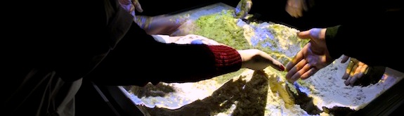
Interactive digital map that combines the earth and the heavens
Interactive digital map that combines the earth and the heavens
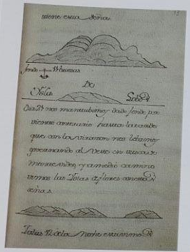
Guayupia is a digital map Jen Lowe and I made as a gift for our kids, featured in Territory Atlas. Named after the Tupi-Guarani concept of guayupia, the Land Without Evil, it draws on native South American cartographic traditions: Quechua sky-maps that track time through the Milky Way's drift, Tupi-Guarani migration paths, and the south-up orientation of Joaquin Torres-Garcia. Made south-up to anchor their geographic first principles in the hemisphere where their family lives, the map weaves together earth, stars, shorelines, and ancestral genealogy into a cosmographical portrait of origin and belonging.
We wanted to show them where they come from, to explain the unlikely fact of their existence. And we wondered: what could a map be?
"A more adequate definition of cartography needs to express not just the presence of geographical knowledge but also cosmographical or biographical information, such as the soul flight of shamans or the passage and pathways of gods, heroes, and ancestors." (Whitehead, 303)
Our research turned up a rich history of native South American mapping, combining earth and stars with humans, plants, animals, and gods into complex cosmographical systems. We learned that the Quechua people tracked time through the Milky Way's nightly and seasonal rotations. We were moved by the mass migrations of the Tupi-Guarani people, who abandoned their villages to follow prophet-shamans in search of a land of immortality and contentment. We found shoreline sketches from European navigators' rutters, drawn to help them recognize harbors that were new to them. We found the south-up maps of Joaquin Torres-Garcia, who inverted the hemisphere to challenge the colonial assumption that north belongs on top.
Our kids' genealogy is vastly more colonialist than native. They are descended from kings and soldiers and factory workers and farmers who crossed the Atlantic, settling the Americas at the cost of native lives and freedoms. Hundreds of years later, we are still traveling to find success, now even more frantically: we move every year and change jobs every few years, each move taking us further from family and friends. In our families, the relentless search for guayupia goes back generations. Does seeing the futility and cost of the search mean we'll call it off? In our hearts, this remains an open question.
We made the map south-up to establish their geographic first principles in the hemisphere where their family lives. We included earth and stars and shorelines to help them find their way to the gods and heroes they will map for themselves.
The sky and stars are fundamental to mapping in native South American cultures.
The sky, both day and night, is perhaps the physical feature most constantly mapped by indigenous people... the relations between the people, animals, and plants on earth are often understood or represented by reference to celestial phenomena. (Whitehead, 304)
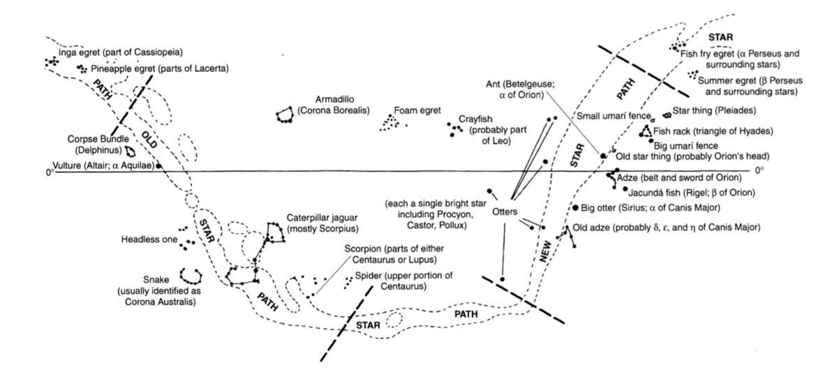 Constellations of Barasana astronomers. (306)
native South American ideas show radically different space-time understandings that challenge a rationalist tradition of opposing the “real” and the “imagined.” (303)
The contrast between modern Western and native South American conceptions might be best summed up by emphasizing that for native South Americans the cosmos and its order constitute a joint project of humanity and divinity. (303)
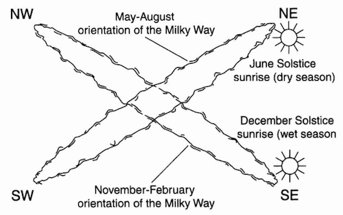
The Milky Way’s apparent nightly and seasonal rotation. (Gartner, 261)
...in the absence of a bright star near the celestial south pole, Quechua peoples and their ancestors organized the sky by reference to the Milky Way, called Mayu or the “celestial river,” and its apparent cruciform rotations. In a twenty-four-hour period, the Milky Way forms two intersecting intercardinal axes that divide the heavens into quarters. Since the plane of the Milky Way is inclined in relation to the earth’s axis, the stars of one quarter will rise as those of the opposite quarter set as the earth rotates. Astronomical phenomena can be tracked with respect to these quarters, which create a systematic means for the spatial and temporal reckoning of the world and its natural and social rhythms. This principle is central to pre-Columbian spatial reckoning. (260)
Traditional South American conceptions of distances were separated into within-the-horizon, and beyond-the-horizon. On the Achuar of Ecuador, and the Warao of Venezuela:
In Achuar culture, the concepts of right and left are used only to indicate an immediate and relative position, longer distances being expressed in the time it takes to cover them. Beyond a local destination, travel time is counted in days or simply becomes “very far,” since the events of a temporally extended journey are unpredictable. (Whitehead, 303)
On their journeys across the sea the Warao could always remain at the center of the universe as the circle of the horizon traveled with them, and, if need be, they could establish a new home wherever two mountains could serve as the poles of their earth and the abode of the earth-gods. (Wilbert, 148)
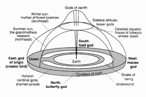
Profile of the Warao universe. (Whitehead, 315)
Native cartography includes both the real and imagined places. On the Tupi-Guarani search for guayupia:
...the search for places whose existence is indicated by cosmological ideas also forms an element of native cartography. The best-known example of this comes from the southern regions of South America and is part of the Tupi-Guarani cultural tradition. This is the spiritual and physical search for guayupia, the Land without Evil. This land of immortality and contentment was a product of the apocalyptic vision of the karai (prophet-shamans), and the hope of its discovery provoked mass migrations among the native people, who abandoned their villages and chiefs to follow the karai in their mystical quest. Such migrations had a uniformly east-west orientation and for some groups were directly identified with Kandire, the Inka empire toward the west. The arrival of the remnants of one of these millenarian migrations in Chachapoyas, Peru, in 1549, provoked an episode in Spanish mystical exploration, for the Spanish joined the Tupi in searching for the kingdom of Omagua, believing it to be El Dorado. (Whitehead, 313; Clastres, 22-24, 49-51)
Navigators included harbor sketches to help them find their way.
Shore views typical of those found in navigators’ rutters. (Dym & Offen, 14)
Uruguayan artist Joaquin Torres-Garcia established The School of The South in 1934, known as El Taller Torres-Garcia (TTG). In 1935, he delivered an anti-colonial lecture announcing TTG, using this south-up map as visual rhetoric.
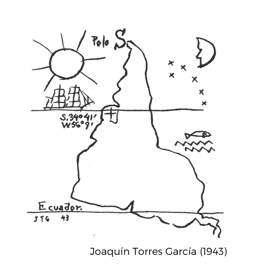
Our geographical position, then, indicates our destiny. And we are responsible for it.
...we can do everything (now I’m referring to the vital things, those we could call telluric, that give the right aspect to everything); and then, not exchange what belongs to us for the foreign (which is unpardonable snobbery) but, on the contrary, convert the foreign into our own substance. Because I believe that the epoch of colonialism and importation is over (I am now referring to culture more than anything else)... (Ramirez, 55)
The Argentine comic artist Quino used the south-up map in his popular comic strip Mafalda.
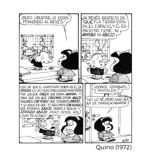
"But Libertad, don't you see. You are putting it upside down!" "Upside down with respect to what? The earth is in space, and in space there is no UP or DOWN." “That thing that the Northern hemisphere is UP is a psychological trick made up by those who believe that they are on TOP, so that those who think they are on the BOTTOM, keep beleiving we are DOWN. The worst is that if we keep thinking we are DOWN we will keep being DOWN. But from today this is over!" "Where have you been Mafalda?" "I don't know, but from now on, this is it!"
Clastres, Helene. The Land-without-Evil: Tupi-Guarani Prophetism. Urbana : University of Illinois Press, 1995.
Dym, Jordana & Offen, Karl. Mapping Latin America: A Cartographic Reader. Chicago; London: The University of Chicago Press, 2011.
Gartner, William Gustav. "6· Mapmaking in the Central Andes." Americas 169 (1970): 647-54.
Ramirez, Mari Carmen. El Taller Torres-García : the School of the South and its Legacy. Austin: Published for the Archer M. Huntington Art Gallery, College of Fine Arts, the University of Texas at Austin by the University of Texas Press, 1992.
Whitehead, Neil L. "Indigenous cartography in lowland South America and the Caribbean." The history of cartography 2.3 (1998): 301-26.
Wilbert, Johannes. “Geography and Telluric Lore of the Orinico Delta.” Journal of Latin American Lore 5 (1979): 129-150